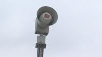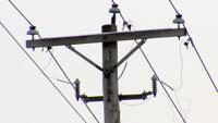
DARLINGTON, Wis. -- Over a hundred customers were without power Wednesday morning as severe thunderstorms made their way across southern Wisconsin.

April 25, 2024 @ 11:29 am

April 25, 2024 @ 4:15 pm

Adjust the ZIP code in the box below to get the forecast for your town
Mostly clear early with increasing clouds late. Wind: SE 8-15 MPH
Mostly clear early with increasing clouds late. Wind: SE 8-15 MPH
Mostly cloudy and breezy with scattered showers and thunderstorms developing. Wind: SE 15-25 MPH, gusts to 30 MPH
Wind: SE @ 10 mph
Precip: 0% Chance
Humidity: 32%
Wind Chill: 58°
Heat Index: 60°
UV Index: 2 Low
Visibility: 10 mi
Wind: ESE @ 11 mph
Precip: 0% Chance
Humidity: 34%
Wind Chill: 57°
Heat Index: 59°
UV Index: 1 Low
Visibility: 10 mi
Wind: ESE @ 10 mph
Precip: 0% Chance
Humidity: 36%
Wind Chill: 55°
Heat Index: 57°
UV Index: 0 Low
Visibility: 10 mi
Wind: ESE @ 10 mph
Precip: 0% Chance
Humidity: 42%
Wind Chill: 49°
Heat Index: 52°
UV Index: 0 Low
Visibility: 10 mi
Wind: ESE @ 9 mph
Precip: 0% Chance
Humidity: 48%
Wind Chill: 44°
Heat Index: 48°
UV Index: 0 Low
Visibility: 10 mi
Wind: ESE @ 9 mph
Precip: 0% Chance
Humidity: 55%
Wind Chill: 41°
Heat Index: 46°
UV Index: 0 Low
Visibility: 10 mi
Wind: ESE @ 9 mph
Precip: 0% Chance
Humidity: 63%
Wind Chill: 39°
Heat Index: 44°
UV Index: 0 Low
Visibility: 10 mi
Wind: ESE @ 9 mph
Precip: 0% Chance
Humidity: 68%
Wind Chill: 38°
Heat Index: 44°
UV Index: 0 Low
Visibility: 10 mi
Wind: ESE @ 9 mph
Precip: 0% Chance
Humidity: 72%
Wind Chill: 37°
Heat Index: 43°
UV Index: 0 Low
Visibility: 10 mi
Wind: ESE @ 9 mph
Precip: 0% Chance
Humidity: 74%
Wind Chill: 37°
Heat Index: 42°
UV Index: 0 Low
Visibility: 10 mi
Wind: ESE @ 10 mph
Precip: 0% Chance
Humidity: 73%
Wind Chill: 36°
Heat Index: 42°
UV Index: 0 Low
Visibility: 10 mi
Wind: SE @ 10 mph
Precip: 0% Chance
Humidity: 74%
Wind Chill: 34°
Heat Index: 34°
UV Index: 0 Low
Visibility: 10 mi


DARLINGTON, Wis. -- Over a hundred customers were without power Wednesday morning as severe thunderstorms made their way across southern Wisconsin.

Powerful storms are rumbling over parts of the southeastern U.S. as more severe weather takes aim at parts of the Ohio Valley. The storm system has already been blamed for at least one death in Mississippi and flooded streets in the New Orleans area. Damage has been reported from Texas to the Florida Panhandle. More than 100,000 customers lack power. Now forecasters say parts of Ohio, Kentucky and West Virginia will be near the bull's-eye of a new area of concern Thursday. The Storm Prediction Center says those areas could see some tornadoes, damaging winds and large hail.

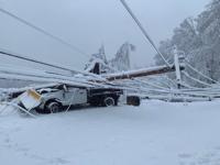
(CNN) — At least three people are dead and hundreds of thousands are without power Friday after a nor’easter brought heavy snow and strong winds to parts of the Northeast.

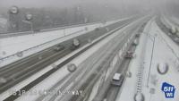
MADISON, Wis. -- Dane County Emergency Management asked residents to avoid travel Tuesday night due to inclement weather.